I've always been interested in maps. The
recent digitization of a collection of historic Shaker Heights maps started me thinking again about what I could do with Google Maps that might be interesting or useful.
I used data from the City of Shaker Heights Landmark Commission's
Summary and Map and
Designation Report for the Winslow Road Historic District to make a more readily accessible map illustrating the district.
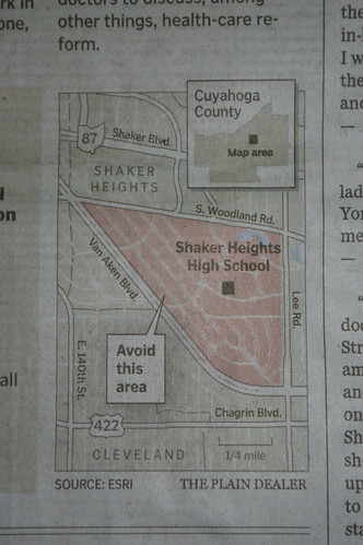
View Winslow Road Historic District in a larger mapThere are two National Register of Historic Places Historic Districts in the immediate proximity - Shaker Square, in Cleveland, and Shaker Village, which encompasses most of the city of Shaker Heights. I used the maps of
Shaker Square and
Shaker Village to create the following two maps, which may hopefully better illustrate the exact boundaries of the districts. My maps are based on the boundaries shown on the official maps, with the exact details based upon my best guesses and knowledge of the area. I'd love to have more detailed original material. It'd be especially interesting to be able to illustrate which structures are contributing resources and which are not. Thanks to Kelly Beck at the Shaker Heights Plannin Department for locating the source maps.
View Shaker Square Historic District in a larger mapView Shaker Village National Register Historic District in a larger mapFinally, right now I'm working on a map of
Shaker Heights City Landmarks. This map includes all local landmarks, as of the end of 2008. I've begun to include photographs of some structures already. I hope to include photographs of them as well in the not too distant future. I may create specific icons for the various types of structures illustrated. I'm not terribly happy with the house icon right now - there's something less than pleasing about using a blob to represent a distinct spot.
View Shaker Heights Landmark Properties in a larger map
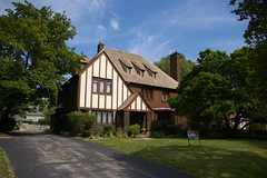 A contributing structure in the Shaker Village Historic District, a National Register of Historic Places historic district.
Built 1926 by Richard U. Collier.
Designed by architect William A. Bingham.
A contributing structure in the Shaker Village Historic District, a National Register of Historic Places historic district.
Built 1926 by Richard U. Collier.
Designed by architect William A. Bingham.